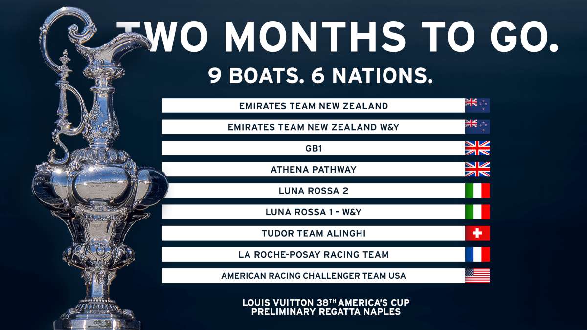
The highlight of this third week has been the rounding of the Kerguelen archipelago which are in the middle of the Indian Ocean. The crew decided to sail north of the islands in order to avoid the drift ice located to their south. Although Spindrift 2 has lost a few miles over the last couple of days, it is mainly due to a zone of light winds ahead, moving at more than twenty knots.
The team is all set to reach Cape Leeuwin tomorrow (Thursday) evening, The second mythical cape on this round-the-world challenge will be quite a way north, as it marks the south-western tip of Australia, roughly 800 miles from the track of the great black and gold trimaran. It is more symbolic than a focal point as the Pacific Ocean only officially starts south of Tasmania, which is two days further on. The 200 miles separating Spindrift 2 from the current holder of the Jules Verne Trophy is not likely to change much over the next few days due to a weather system that limits the choice of course.
Dona Bertarelli, Yann Guichard and their crew of twelve have had no choice but to remain in a corridor of westerly winds between 49° and 52° South since their northern passage of the Kerguelen archipelago. Ahead of Spindrift 2, a zone with a weak pressure gradient is moving at practically the same speed as the boat. This means that the crew is constantly stuck in the same weather system and cannot expect to accelerate until a low from Madagascar kicks in and sweeps south of Australia on Thursday evening. After last night’s gybe, the big trimaran should be changing course this afternoon to follow a track parallel to her virtual predecessor. Thereafter, she will gradually sail up to the 45° parallel south to latch onto these strong new north-westerly winds in front of this tropical depression.
Between ice and shallow waters

The acceleration of the boat will be marked and lasting! Based on current forecasts, Spindrift 2 could make up the time lost to Banque Populaire V before entering the Pacific Ocean and even continue to benefit from the powerful north-west stream south of New Zealand, if not beyond.
The good news is that the area of drift ice that forced Yann Guichard and his crew to keep north of the southern archipelago is now behind them. The latest satellite images indicate that the icebergs are now concentrated below the Kerguelen islands (Indian Ocean), a long way south of New Zealand (Pacific Ocean) and between the Falklands and South Georgia islands (Atlantic Ocean). So, as it turns out, the detour to the north did not really slow Spindrift 2 down too much given the conditions at the time. Apart from the risk of colliding with a growler (a piece of ice weighing several tonnes), the sea state did not make it possible to sail fast on a southern course.
The way ahead of the giant trimaran’s bows is clear to Cape Horn at least, and Yann Guichard’s crew has free rein to make the most of favourable conditions from Friday before attacking the “real toughie” of this circumnavigation via the three capes next weekend, the Pacific Ocean!